• RFQ
  • Calendar
  • Gallery
  • Partners
  • Glossary
  • Contact
  • Agriculture
    • Basin CoAgMet
  • Municipal & Industrial
    • Water Conservation
    • Drinking Water Providers
    • Conservation Planning
    • Land Use & Water
  • Recreation
    • Special Value Waters
    • Streamflow Gages
  • Environment
  • Funding
  • Water Planning
    • Colorado Water Plan
    • 2022 Basin Implementation Plan Update
    • 2015 Basin Implementation Plan
      • Grand County
      • Summit County
      • State Bridge
      • Eagle River
      • Middle Colorado
      • Roaring Fork
      • Grand Valley
    • Climate Plan
    • Watershed Planning
    • Stream Management
    • Demand Management
    • Big River Issues
    • Snow Report
  • Water Quality
    • Salinity & Selenium
    • Pollution Management
    • NWCCOG
  • About
    • Contact
    • Members
    • PEPO
    • CBRT By-Laws
    • Colorado Basin Facts
    • Meeting Minutes
    • Reports & Documents
  • Search
  • Menu Menu

Grand County

Home1 / Water Planning2 / Colorado Basin Implementation Plan3 / Grand County
  • Water Management
  • 2022 BIP Update
  • 2015 BIP
  • Grand County
  • Summit County
  • State Bridge
  • Eagle River
  • Middle Colorado
  • Roaring Fork
  • Grand Valley

Grand County Implementation Plan

Developed as part of the Colorado Basin Implementation Plan, which in turn contributed to Colorado’s statewide Water Plan.

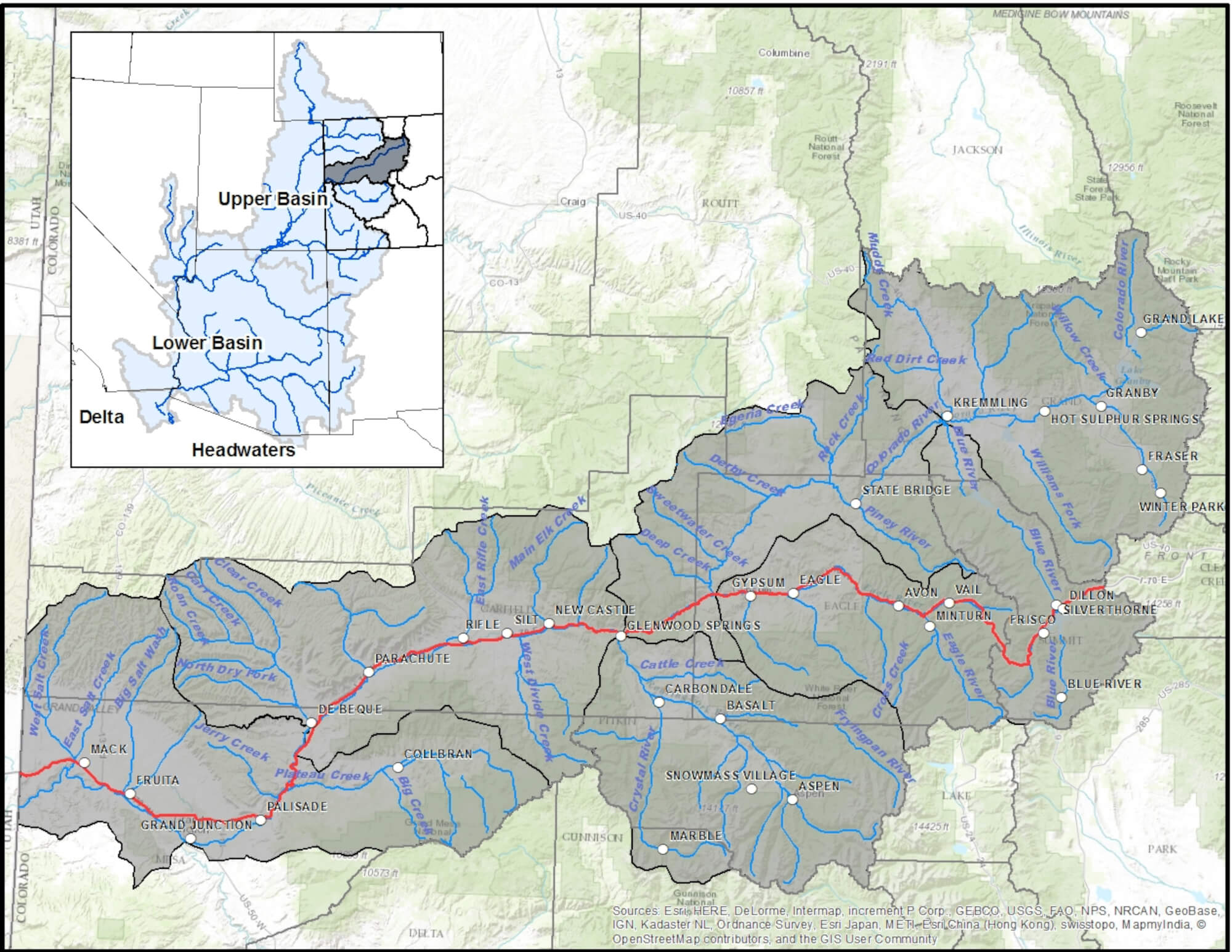
The Grand County Region consists of the Fraser and the Upper Colorado River watersheds and follows the boundary of Grand County. This region is the most impacted region in the Colorado basin from Transmountain Diversions (TMDs). The major TMDs include:

  • Northern Water Conservancy Districts Colorado Big Thompson Project (C-BT) which diverts water through the Alva B. Adams Tunnel at Grand Lake (BOR, 2014)
  • Windy Gap Project (Northern Water, 2014) sponsored by Northern Water, diverts water through a pump back system to Lake Granby and is delivered to water users via the C-BT project
  • Moffat Collection System which diverts water above Winter Park through the Moffat Tunnel (Denver Water, 2014) and the Williams Fork Basin sponsored by Denver Water
  • Grand Ditch, a diversion project in the Never Summer Mountains, delivers water to the Cache La Poudre River via a 14.3 mile long ditch

The diversions out of Grand County amount to more than 300,000 AFY, more than three times the amount from any other region in the Colorado Basin. On average, more than 60% of the Fraser River is diverted out of the Basin above Tabernash (Ranch Creek Confluence).

Water providers in the upper Fraser River Valley are vulnerable to extended droughts, lack of redundancy, regulatory changes from Groundwater Under the Direct Influence (GWUDI) classifications, further firming from Denver’s Moffat Collection Project and lack of upstream reservoir storage that can be used for physical water. Further, Grand County water providers experience large fluctuations in demand due to the tourist/recreational seasonal economy.

The protection and restoration of the Fraser and upper Colorado Rivers are critical needs for Grand County. Recent studies and reports including the Upper Colorado River Basin Study (UPCO) (Hydrosphere Resource Consultants, 2003) investigated water quantity and quality issues in Grand and Summit Counties. The Grand County Stream Management Plan (Tetra Tech, et. al., 2010) developed a framework for maintaining a healthy stream system in Grand County and has been used extensively to assist Grand County in recent negotiation for the Colorado River Cooperative Agreement (CRCA) and the Windy Gap Firming Projects. Many of the projects listed in the Grand County Region tables have come from these agreements.

Colorado Water Plan

View Plan

Several projects listed include possible new small reservoirs above the physical diversion locations. Regulatory restrictions, high costs and variable geologic conditions have prevented proceeding with these conditional storage rights. This BIP recommends that State, Federal and Local regulatory jurisdictions work collaboratively to improve the permitting process. Collaboration among the water users in the Fraser Valley, Grand County, Middle Park Water Conservancy District, Denver Water, Winter Park Recreation Association, CWCB (minimum instream flow program) and others should occur in order to permit and build these small reservoirs to provide redundant water supplies.

Water providers in the upper Fraser Valley should consider interconnected water systems which would have multiple benefits to all users. The Grand Valley Water Council and the Eagle River Water and Sanitation District (ERWSD) are good examples that could be followed to guide these interconnections. The cooperation and interconnections would result in multiple supplies and redundancy that could protect water users from extended droughts, impacts from climate change and upstream spills in the Fraser River.

The Fraser Valley will incur growth over the next 35 years to 2050. Existing water providers and municipalities have land use planning and water master planning in place. If land use and growth occurs outside of these planned areas where plans do not exist, the development of physical and legal water supplies will be challenging and will further stress specific reaches of the Fraser River. A land use/water supply study should be undertaken to develop plans in the Fraser River that would result in better collaboration on reservoir planning and municipal water distribution system interconnections in the upper Fraser River. The lower Fraser River water providers should continue to work toward consolidation and interconnecting water systems.

Colorado Basin Implementation Plan

View Plan

Region Themes

Grand County Region


Consumptive Uses

Grand County Region


Environmental & Recreational Conditions

Themes and
Supporting Vulnerabilities
MethodsIdentified Projects
Protect and Restore Healthy Streams, Rivers, Lakes and Riparian Areas

  • Aquatic environmental habitat degradation
  • Unmet instream/nonconsumptive flows
  • Impacts to tourism and recreation economies1
  • Impacts by existing and potential additional transmountain and in-basin diversions
  • Agreed proposed benefits vulnerable to Moffat & Windy Gap projects implementation
  • Collapsing ecosystems due to low flows, degrading water quality and non-optimal temperatures
  • Preserve Water Conservancy Act
  • Grand County Stream Management Plan, CRCA, Grand Lake Clarity MOU, Windy Gap
  • Firming Project IGA, and UPCO Study
  • If firming projects proceed, all conditions of signed agreements must be completed
  • If firming projects do not proceed, identify projects for mitigation
  • Local government land use authority
  • Restore Upper Colorado River above the confluence with the Blue River
  • Tourism and recreation economy1 needs and funding opportunities
  • Review proposed benefits from mitigation actions of Moffat and Windy Gap projects
  • Learning By Doing to direct, coordinate and apply resources
  • Regional Section 208 Water Quality Management Plan
  • CRCA identified projects
  • Windy Gap Firming Project IGA identified projects
  • UPCO Study identified projects
  • Grand County Stream Management Plan identified projects
  • Water provider conservation projects
  • Bypass of Windy Gap Reservoir
  • Upper Colorado River Irrigation and Restoration Project Phase 1 (KB Ditch to Blue River) and Phase 2 (TMDs on the Fraser and Colorado River to the confluence with the Blue River)
  • Grand Lake Clarity Umbrella Agreement Projects
  • Grand County RICDs
  • Wild and Scenic River Stakeholder Group Plan
  • Implement transmountain diversion bypass flow projects
  • Jones 1 Reservoir
Sustain Agriculture

  • Reduced agriculture irrigated acres
  • Purchase of agricultural water rights by East Slope entities
  • Impacts by existing and potential additional transmountain and in-basin diversions
  • Existing and potential shortages
  • Use suggestions presented in the Agriculture Toolbox2,3,4
  • Expand HUP to include Slot Group
  • Restore Irrigation Infrastructure and Irrigated Lands that have been damaged from TMDs above the confluence with the Blue River
  • Protect West Slope agricultural values
  • Studies identifying existing and potential shortages
  • Protect Green Mountain Operation Policy
  • Increase raw water storage
  • Coordinate exchange potential between users and CWCB
  • Hay Park Conduit and Reservoir
  • Protect Slot Group
  • Big Lake Ditch Study
  • Upper Colorado River Irrigation and Restoration Assessment projects
  • Sunset Ridge Pond
  • Upper Colorado River Irrigation and Restoration Project Phase 1 (KB Ditch to Blue River) and Phase 2 (TMDs on the Fraser and Colorado River to the confluence with the Blue River)
Secure Safe Drinking Water

  • Source water degradation
  • Lack of redundancy in drinking water supplies
  • Extended drought
  • Forest Service bypass in Fraser Valley
  • GWUDI classification on drinking water wells
  • Important junior municipal water rights being called out by senior right
  • Follow recommendations documented in local source watershed protection/forest health studies and plans
  • Water providers should work with neighboring entities to provide a redundant water supply
  • Maintain Forest Service bypass
  • Create redundancy for individual users/ storage
  • Coordinate exchange potential between users and CWCB
  • Protect Green Mountain Operation Policy
  • Protect Green Mountain Slot Group
  • Granby/SCWWW Authority Permanent drinking water systems connection
  • Fraser/Winter Park drinking water systems connection
  • Winter Park Reservoir No. 2 Enlargement
  • Jones 1 Reservoir
  • Hay Park Conduit and Reservoir
  • Implement CRCA identified projects
  • Implement Windy Gap Firming IGA and Firming of Middle Park Windy Gap water
  • Ranch Creek Reservoir
  • Expand HUP to include Slot Group
  • Grand County W&S Reservoirs Nos. 1 & 2
  • Fraser River Pumpbacks
Develop Local Water Conscious Land Use Strategies

  • Growth development impacting water supplies and nonconsumptive needs
  • Limiting development to within urban boundaries
  • Promote water conscious growth development through improved land use policies
  • Grand County Master Plan land use revisions
  • Winter Park changes to land use policy

(The above information was extracted from the Colorado Basin Implementation Plan and edited slightly to fit)

Help

Home
About
Members
Partners
Basin Facts
Streamflow Gages
Snow Report
Meeting Calendar
Contact

Learn

Colorado Water Plan
Basin Implementation Plan (BIP)
CBRT BIP Update
Colorado Climate Plan
Agriculture
Municipal & Industrial
Recreation
Environment
Water Planning
Water Quality

Address

Colorado Basin Roundtable
℅ Colorado River Water Conservation District
201 Centennial Street, Suite 200
Glenwood Springs, Colorado 81601

Protecting Agriculture, Environment, Recreation & Water Supply for Western Colorado.

Colorado state flag
© 2022 Colorado Basin Roundtable - All Rights Reserved  |  Web Design by Goofyfooter Solutions
  • Privacy Policy
  • Accessibility
Scroll to top
Skip to content
Open toolbar

Accessibility Tools

  • Increase Text
  • Decrease Text
  • Grayscale
  • High Contrast
  • Negative Contrast
  • Light Background
  • Links Underline
  • Readable Font
  • Reset
  • Help
  • Feedback